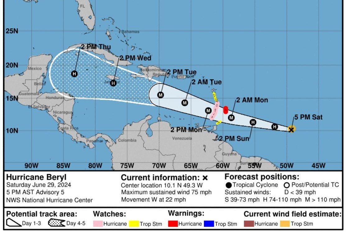
Beryl’s projected path. Map courtesy National Hurricane Center
June 29 (UPI) — Beryl became the Atlantic’s first hurricane of the season Saturday, and is forecast to become a major storm.
The second named storm of the year intensified from a depression into a hurricane in one day.
In its 5 p.m. EDT advisory Friday, the National Hurricane Center listed Bery as depression with sustained winds of 35 mph.
In its 11 p.m. EDT advisory Friday, the NHC listed Beryl as a tropical storm with sustained winds of 40 mph and was moving west at 18 mph, about 1,110 miles east-southeast of Barbados.
In the 5 p.m. update Saturday, the storm was upgraded to a hurricane with sustained winds of 75 mph, three hours after they were 65 mph. Beryl was 785 miles east-southwest of Barbados and was moving 22 mph westward.
By 8 p.m., the storm was moving at a consistent speed about 660 miles east-southeast of Barbados, with maximum sustained winds of 80 mph.
A hurricane warning is in effect for Barbados, St. Lucia, St. Vincent and the Grenadine Islands, and Grenada. A tropical storm warning is in effect for Martinique and Tobago, and a tropical storm watch is in effect for Dominica.
Tropical-storm-force winds extend outward up to 45 miles from the center.
On the west-northwest forecast track, the system is expected to move across the Windward Islands late Sunday night and Monday where it will become “a dangerous major hurricane” with hurricane-force winds and life-threatening storm surge before it is forecast to weaken, NHC said.
“Satellite images show an expanding central dense overcast feature, and recent microwave images indicate that a partial eyewall has formed, NHC forecaster NHC Stevs Cangialosi said. “Beryl is a compact tropical cyclone, with its tropical-storm-force winds estimated to extend up to 50 nautical miles from the center.”
Beryl is expected to produce rainfall totals of 3 to 6 inches across Barbados and the Windward Islands. This rainfall may cause flooding in vulnerable areas.
The first hurricane usually isn’t reached until Aug. 11, Fox Weather reported.
Only seven named storms have formed over the last 173 years in this sector of the Atlantic before July 4, according to Accuweather.
AccuWeather hurricane experts are forecasting the United States to avoid impacts from the storm.
“Direct impacts to the United States look unlikely; however, it is very important to note that if the high pressure across the Southeast weakens, that can allow the storm to move farther north and potentially directly impact the Gulf Coast,” AccuWeather Lead Hurricane Forecaster Alex DaSilva said.
The first tropical storm, Alberto, made landfall over Mexico on June 20 and then pummeled Texas the next day with rain.
A low pressure to the east of Beryl, several hundred miles southwest of the Cabo Verde Islands, has a 30 percent chance of cyclone formation over 48 hours, according to NHC.
“This storm is expected to follow a track very similar to Beryl and can be near the Lesser Antilles around July 3-4 and could eventually bring very heavy rain to portions of the Greater Antilles,” DaSilva said.
Another potential developing storm is located over the Yucatan Peninsula, and its projected path will take over nearly the same locations where Tropical Storm Alberto tracked earlier this month. The NHC gives it a 50 percent of cyclone formation in the next 48 hours.

